What do we call something which connects one place to the other? In the western world, there are so many names given to them. It could be termed as road, street, drive or route.
In today’s modern world, it has become very easy to commute from one place to another. But can we imagine what must have been like 5000 years ago? With practically zero infrastructure and unavailability of vehicles, how would people commute and more importantly how the trade will happen?
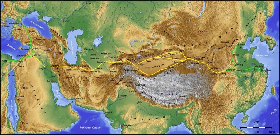
All of us have heard about the famous Silk Route which spans 6500 kms from Greece to China. However it generally bypassed the Indian Subcontinent. This road was active from the second century BCE. But do you know of a road which is far older than even the Silk Route? The Buddhist literature and Indian epics such as Mahabharata refer to the existence of such roads much before the Mauryan Empire and was called "Uttarapatha" or the "Northern Road". The road connected the eastern region of India with Central Asia, the terminus of the Khorasan Road. Even Panini has mentioned the existence of such roads.
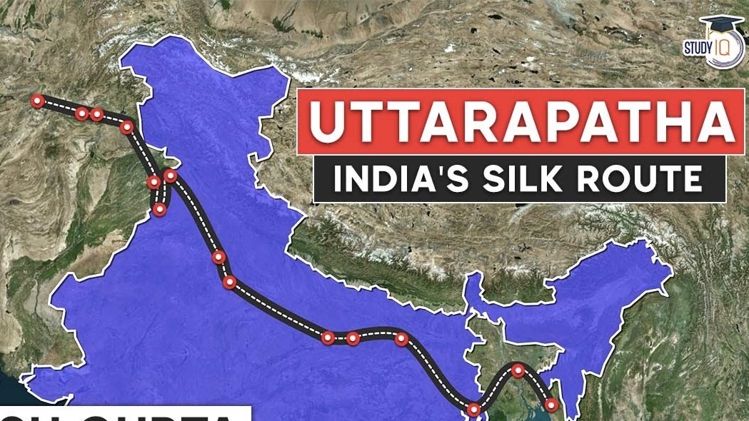
I am sure hardly anyone has heard of Uttarapath. But will some bell ring if I say Grand Trunk Road? Well, this is the modern name of Uttarapath. This road was also known as Sadak-e-Azam, Shah Rah-e-Azam, Badshahi Sadak, and Long Walk during different times of the history.
Uttarapath is one of Asia's oldest and longest major roads. For at least 5000 years। It has linked Central Asia to the Indian subcontinent. It runs roughly 3,655 km (2,271 mi) from Teknaf, Bangladesh on the border with Myanmar in the east, going west all the way to Kabul, Afghanistan, passing through Chittagong and Dhaka in Bangladesh, Kolkata, Varanasi, Prayagraj, Kanpur, Agra, Aligarh, Delhi, Sonipat, Panipat, Karnal, Ambala, Ludhiana, Jalandhar, Chandigarh, Amritsar in India, and Lahore, Gujranwala, Jhelum, Rawalpindi, and Peshawar in Pakistan and Jalalabad, Kabul in Afghanistan.
Mauryan Empire
The precursor of the modern Grand Trunk road was built on the orders of the emperor Chandragupta Maurya and was inspired by the Persian Royal Road, (more precisely, its eastern stretch, the Great Khorasan Road that ran from Media to Bactria). During the time of the Mauryan Empire in the 3rd century BCE, overland trade between India and several parts of Western Asia and Bactria world went through the cities of the north-west, primarily Takshashila and Purushapura (present-day Taxila and Peshawar respectively, in Pakistan). Takshashila was well connected by roads with other parts of the Mauryan Empire. The Mauryas had maintained this very ancient highway from Takshashila to Patliputra (present-day Patna in India). Chandragupta Maurya had a whole army of officials overseeing the maintenance of this road as told by the Greek diplomat Megasthenes who spent fifteen years at the Mauryan court. Constructed in eight stages, this road is said to have connected the cities of Purushapura, Takshashila, Hastinapura, Kanyakubja, Prayag, Patliputra and Tamralipta, a distance of around 2,600 kilometres (1,600 mi).
The route of Chandragupta was built over the ancient "Uttarapatha" or the Northern Road. The emperor Ashoka had it recorded in his edict about having trees planted, wells built at every half kos and many "nimisdhayas", which is often translated as rest-houses along the route for the travelers. The emperor Kanishka is also known to have controlled the Uttarapatha.
Suri and Mughal Empires
Sher Shah Suri, the medieval ruler of the Sur Empire, took to repairing The Chandragupta's Royal Road in the 16th century. The old route was further rerouted at Sonargaon and Rohtas and its breadth increased, a sarai was built, the number of kos minars and baolis increased. Gardens were also built alongside some sections of the highway. Those who stopped at the sarai were provided food for free. His son Islam Shah Suri constructed an additional sarai in-between every sarai originally built by Sher Shah Suri on the road toward Bengal. More sarais were built under the Mughals. Jahangir under his reign issued a decree that all sarais be built of burnt brick and stone. Broad-leaved trees were planted in the stretch between Lahore and Agra and he built bridges over all water bodies that were situated on the path of the highways. The route was referred to as "Sadak-e-Azam" by Suri and "Badshahi Sadak" by the Mughals. The Afghan end of the road was rebuilt under Mahmud Shah Durrani. The road was considerably rebuilt in the British period between 1833 and 1860.
British Empire
In the 1830s the East India Company started a program of metalled road construction, for both commercial and administrative purposes. The road, now named the Grand Trunk Road, from Calcutta, through Delhi, to Kabul, Afghanistan was rebuilt at a cost of £1000/mile.
The road is mentioned in a number of literary works including those of Foster and Rudyard Kipling. Kipling described the road as: "Look! Look again! and chumars, bankers and tinkers, barbers and bunnias, pilgrims – and potters – all the world going and coming. It is to me as a river from which I am withdrawn like a log after a flood. And truly the Grand Trunk Road is a wonderful spectacle. It runs straight, bearing without crowding India's traffic for fifteen hundred miles – such a river of life as nowhere else exists in the world."
Republic of India
The Grand Trunk Road is still used for transportation in the present-day Indian subcontinent, where parts of the road have been widened and included in the national highway system.
The road coincides with the current N1, Feni (Chittagong to Dhaka), N4 & N405 (Dhaka to Sirajganj), N507 (Sirajganj to Natore) and N6 (Natore to Rajshahi towards Purnea in India; NH 112 (Purnea to Bakkhali), NH 27 (Purnea to Patna), NH 19 (Kolkata to Agra), NH 44 (Agra to Jalandhar via New Delhi, Panipat, Karnal, Ambala and Ludhiana) and NH 3 (Jalandhar to Attari, Amritsar in India towards Lahore in Pakistan) via Wagah; N-5 (Lahore, Gujranwala, Gujrat, Lalamusa, Kharian, Jhelum, Rawalpindi, Peshawar and Khyber Pass towards Jalalabad in Afghanistan) in Pakistan and AH1 (Torkham-Jalalabad to Kabul) to Ghazni in Afghanistan.
Over the centuries, the Uttarapath or The Grand Trunk Road has remained as one of the major trade routes in the region and facilitated both travel and postal communication.
@ Yeshwant Marathe
yeshwant.marathe@gmail.com